Why time zones do not follow state borders or a logical North South longitude demarcation is rather interesting? Look at a time zone map; the lines are all over the place. I can understand a few East-West states like Kentucky and Tennessee where the line splits the state in two they’d be in different zones, but look at Idaho and Oregon. The top half of Idaho is Pacific and the rest is Mountain (no wonder the top half always wants to secede) and one tiny chunk of Oregon is in Mountain zone time. Makes no sense. 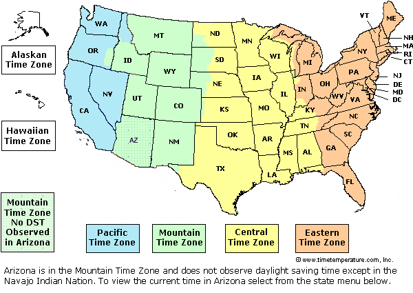
That got me to looking at the borders themselves.Some are easy, Wisconsin is separated from Iowa by the Mississippi River and Washington is separated from Idaho by the Columbia. Most however are based on artificial political tradeoffs and make fascinating reading. Some have interesting and weird cuts into their neighbors’ e.g., Mass into Connecticut and the boundaries of Arkansas and Oklahoma simply make no sense. Panhandle me all the way to Nevada and rename Oklahoma state to ‘Long and Skinny.’
Most of this is documented and enjoyable to research. Politics at its best. Just check into the WA Pig War. As for border oddities check out Point Roberts? WA.

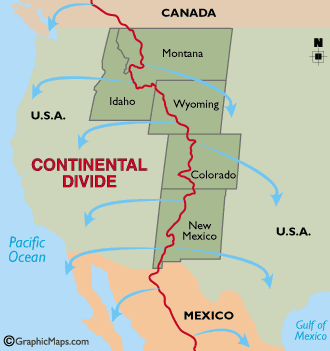
Originally the western border of Montana was to be the Continental Divide. It started well in the south but then veers west to the Bitter-root Mountains, hundreds of miles away from the Divide. Oops. Was it a surveying mistake? I think the supposed “mistake” was deliberate, and gave Montana the mineral load that should have belonged to Idaho. “Treasure States” can be formed by a simple surveyor’s drunken error or by political graft.
IMO this might have been a smarter division of the States esp. Colorado and perhaps New Mexico where divisions between East and West have been ongoing problems. Northern CA might be another case in point. The Sacramento River might be a logical division point between North and South.
The more and more I look at Idaho it looks like a state of leftovers. I suppose the Snake River involves its Southern border and then Oregon.
Some Eastern states such as Georgia are based on the original land grants from the King. Considering the politics between England, France and Spain these could be tricky issues.
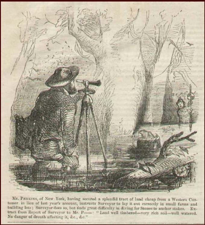
In the west most did not not have the most professional surveyors do their border for them. A good example being Aurora, a ghost town in Nevada. It was for a time, the county seat for Mono County in California, until the official survey of the border showed it was 3 miles into Nevada. OOPS again!
As for the weird jogs of state lines around the Mississippi most of those are because the river changed course and parts of Kentucky or other places are now on the wrong side of the river. I suppose the Madrid earthquake may have had a shaky hand in this.
Returning to Washington state. I am reminded that dumb politicians existed back in our earlier days. “The 1844 Democratic presidential candidate James K. Polk ran on a platform of taking control over the entire Oregon Territory and used the famous campaign slogan, “Fifty-four Forty or Fight!“ HE WON! the election at least. Mind you, the British would have had something to say about taking away Vancouver, B.C. and most of the habitable lands of Canada. His plan was to claim and go to war over the entire territory for the United States. Sounds downright American – and much smarter than Iraq or Afghanistan. A quick dirty war and by negotiations we could have had B.C. connecting us to Alaska.
They finally compromised on the 49th parallel in 1846.
Sadly they excluded the southern part of Vancouver Island which was only a colony at that time. Had the Civil War not come about, WA state might well be owning more Islands in the straits,Victoria (now the capital of B.C.) and Sooke which has a nice military base. The USA realized that they could not have a hostile British force to the north while dealing with the breakaway South. Damn, what a lost opportunity, better yet we might have a Victoria with a sewage treatment center instead of it being an export item to the straits. My own take on Victoria is here!
(C) Herb Senft 2014
Now, the following is web stuff regarding Indian names of states, but before I go into that I would say that I’m tired of looking at the U.S. map and seeing all of the illogical naming inconsistencies that result from history or bad divorces.
First of all, take North/South (state) names like North Dakota and South Dakota, and turn them into a single state of Dakota. Same with North and South Carolina into just Carolina. Yah, I know they hate each other. Thankfully we have only a few of those except CA is trying hard to catch up and East West antagonisms pop up everywhere.
I particularly rail at having two states that have the same word in it. Recombine West Virginia and Virginia into one state like it used to be in the good old days. BTW – “The state of Virginia was named after England’s Queen Elizabeth I. In the early 1600’s, all of North America that was not Spanish or French was then called “Virginia” in honor of “The Virgin Queen,” Nope, no Queen Virginia.
States also were named or renamed after:
1. places in Europe like New York, ‘New” Jersey or Rhode Island.
2. American heroes like Washington, but what the heck happened to Jefferson or Jackson?
3, Some states such as California, have made-up names with no meaning at all. La La land once again! Throw in Florida, Maryland, Connecticut etc.
4. Their founding fathers such as William Penn, Pennsylvania
I will also quibble about the Indian name interpretations below. Take your pick. Sometimes its bloody simple. Arizona was Aridzona and Missouri was simply Misery to most settlers. And how could Wyoming come from Chwewamink?
5. Many states have Native American origin: ????
| State’s Name: | Native American Origin: |
| Alabama | Alabama is the name of an Indian tribe native to the state. This tribal name may have come from the word albina, which means “campsite” in their own language, or from the words alba amo, which mean “clearing brush.” |
| Alaska | Alaxsxix, which is a name from the Aleut language. This name means “place the sea crashes against.” |
| Arizona | Arizonac, which is a Spanish corruption of a local Indian name– possibly the Tohono O’odham word alishonag, which means “little spring.” |
| Arkansas | Acansa, which is the name of a Quapaw Indian town. Literally the name means “southern place.” |
| Connecticut | Quinnitukqut, which is the Mohegan Indian name for the Connecticut River. Literally the name means “long river.” |
| Illinois | Illiniwek, which is the tribal name of the Illini tribe. Literally the name means “best people.” |
| Iowa | Ayuhwa, which is one of the tribal names of the Ioway Indian tribe. Literally the name means “sleepy ones.” |
| Kansas | Kansa, which is the name of the Kansa Indian tribe. Literally the name means “south” and is a shortened form of their own tribal name for themselves, People of the South Wind. |
| Kentucky | Kentake, which is an Iroquois placename meaning “meadow land.” |
| Massachusetts | Massachuset, which is a Wampanoag Indian name meaning “by the range of hills.” |
| Michigan | Mshigem or Misigami, which are the native names for Lake Michigan in the Potawatomi and Ojibwe languages. Both names mean “great lake.” |
| Minnesota | Mnisota, which is the native name of the Minnesota River in the Dakota Sioux language. Literally the name means “cloudy water.” |
| Mississippi | Misiziibi, which is the native name of the Mississippi River in the Ojibwe language. Ojibwe is not actually a native language of Mississippi state– the language is spoken near the source of the Mississippi River in Minnesota, which is where the river got its name, and the state was later named after the river. Literally the name means “great river.” |
| Missouri | Missouria is the name of an Indian tribe native to the state. Their tribal name came from the word mihsoori, which means “big canoe people.” |
| Nebraska | Nibthaska or Nibrathka, which are the native names for the Platte River in the Omaha-Ponca and Otoe languages. Both names mean “flat river.” |
| New Mexico | Of course, New Mexico was named after the country of Mexico, but since Mexico itself is named after an American Indian word, the state of New Mexico is also! Mexico is a placename from the Aztec Indian language (Nahuatl.) It literally means “city of the Aztecs.” |
| North Dakota | Dakota, which is the tribal name of the Dakota Sioux Indians. Literally the name means “the allies.” |
| Ohio | Ohiyo, which is the name of the Ohio River in the Seneca Indian language. Literally the name means “it is beautiful.” |
| Oklahoma | Okla Homma, which means “Red People” in the Choctaw Indian language. |
| Oregon | This was a name given by early American settlers to the Columbia River. It was probably a Native American name which the settlers brought with them from another state, since it does not resemble names from the Native American languages of Oregon. It may have meant “beautiful river” in an eastern Algonquian language. |
| South Dakota | Dakota, which is the tribal name of the Dakota Sioux Indians. Literally the name means “the allies.” |
| Tennessee | Tanasi, which was the name of a Cherokee Indian town in the region. Although “Tanasi” was recorded as the Cherokee name of this town, it does not specifically mean anything in the Cherokee language (just as many English place names are not specific words.) It may have been a shortened form of a longer Cherokee word or phrase, or it may have been named after a Cherokee person. |
| Texas | Taysha, which means “friend” in the Caddo Indian language. |
| Utah | Ute is the name of an Indian tribe native to the state. This tribal name may have come from the word nuutsiu, which means “the people” in their own language. |
| Wisconsin | Wishkonsing, which is the Ojibwe name for the Wisconsin River. However, this word does not have a specific meaning in the Ojibwe language, and none of the Ojibwe Indians in our organization knows any oral traditions about where the name came from. |
| Wyoming | Chwewamink, which means “by the big river flat” in the Lenape Indian tribe. The Lenape Indians never actually lived in Wyoming– it was originally the name of a town in Pennsylvania, and white settlers from that area brought the name with them when they moved west. |
Like the WA Redskins Obama by executive order has suggested that states change their names to something that won’t be “deemed offensive.” Kiss all those suckers goodby.
Throw in local names and we might just as well throw away our National Geographics and old maps. Latino names might be next. No Tex America for sure.
Weird thing some Liberal states such as WA are totally enthralled about renaming old historical European explorer names to placate the tribes. Jaun de Fuca straight is now the Salish Sea. Local names in my community in Clallam county are also reverting. Will Pt. Townsend, Mt. Baker, Mt. Rainer be next?
And if you give a UTE about this, please comment!